REGION · HORN OF AFRICA
LAT 14.2417°N · LNG 038.5000°E
STATUS · ACTIVE INVESTIGATION
SENSOR · SATINT / SOCMINT / HUMINT
ZONES · TIGRAY / AMHARA / OROMIA
KHTHON · GEOINT UNIT
13:52:31 UTC

Khthon · Active Investigation

Ethiopia

NOV 20
Tigray war onset
TIGRAY
Primary focus
ACCESS
Severely restricted

Khthon's Ethiopia casework documents massacre sites from the Tigray war (2020–2022), beginning with Adi Hageray, Dengelat, Axum, and Mahbere Dego. Each is reconstructed after the fact from open-source video, satellite imagery, and witness testimony — the only record available once a communications blackout and months-long access delays had already closed the window on a contemporaneous crime scene.

Published Reports

Sort
GEOSPATIAL VIEW · ETHIOPIA — TIGRAY 14.0000°N 038.7000°E
MODE · GEOINT
SENSOR · SAR / SOCMINT

Situation Overview

A Recurring
Pattern

Khthon's Ethiopia casework spans the Tigray war (2020–2022), beginning with the Adi Hageray house-to-house killings (Nov 12–18, 2020), the Dengelat church massacre during the Tsion Maryam festival (Nov 30–Dec 2, 2020), the Axum massacre across three church sites (Nov 28–29, 2020), and the Mahbere Dego cliff execution (March 2021) — documented incidents involving Ethiopian National Defence Force, Eritrean Defence Force, and mixed-command operations.

A consistent pattern runs through this casework: killings at sites the community could not immediately access — a cliff edge, an occupied village, a besieged church — followed by a delay of days to months before bodies could be recovered or buried at all. That delay is what shapes Khthon's evidence base. By the time investigation is possible, the primary record is what survives in open-source video, satellite imagery, and witness testimony gathered after the fact — not a crime scene.

Confidence varies by site. Axum and Mahbere Dego show clear before/after ground disturbance at named churches. Dengelat has a witness-confirmed grave-site coordinate but no individually identifiable graves. Adi Hageray is the outlier: reports that bodies were burned rather than buried mean Khthon has not identified a grave site there, and the assessment says so directly rather than assigning one.

GEOINT Methodology

How These Sites
Were Confirmed

Each Ethiopia report combines a different mix of the same core techniques, applied to whatever evidence a given site left behind.

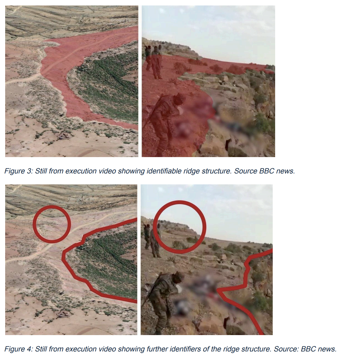
  • Video-to-terrain geolocation. At Mahbere Dego, ridgeline and terrain features visible in circulating execution footage were matched against satellite imagery and 3D terrain models to confirm the cliff site's exact location.
  • Before/after churchyard comparison. At Axum and Mahbere Dego, historical satellite imagery captured roughly two months apart across five churches was compared for ground disturbance, elevated terrain, and surface irregularities consistent with mass burial.
  • Toponym translation and witness-marker triangulation. At Dengelat, Tigrinya-language map labels were translated to locate an unmapped village via its school, and a witness-placed marker shared with CNN was used to fix the grave-area coordinate on satellite imagery.
  • Reporting negative results. At Adi Hageray, satellite imagery of the likeliest burial site did not show clear ground disturbance. Khthon's assessment reflects that directly — moderate likelihood, not confirmation — rather than defaulting to the pattern seen elsewhere.

Methods Applied Across This Casework

Terrain Matching,
Churchyards, Translation

01 · GEOINT

Video-to-Terrain Geolocation

Circulating execution footage rarely comes with a location. At Mahbere Dego, Khthon matched the ridgeline and cliff structure visible in the video against satellite imagery and 3D terrain models to confirm the site — the same approach used to verify the massacre depicted at the Axum churches.

02 · SATINT

Churchyard Time-Series Comparison

Five churches across the two confirmed burial cases — Axum Tsion St. Mary's, Arbatu Ensessa, and Abune Aregawi, plus Mahbere Tsadkan and a second site near Mahbere Dego — were assessed by comparing satellite imagery from before and after the massacre dates for ground disturbance, elevated terrain, and surface irregularity consistent with mass burial.

03 · HUMINT / OSINT

Translation and Witness Markers

Dengelat village did not appear on Google Maps under that name; translating the Tigrinya labels on nearby churches located it via an adjacent school. The grave-area coordinate itself came from a witness who placed physical markers at the site for CNN to locate on satellite imagery — evidence Khthon independently verified rather than generated.

03 · Timeline

Conflict Timeline

NOV 2020

Tigray war begins — federal offensive and early massacres

Ethiopian federal forces and Eritrean troops launch a military offensive against the Tigray People's Liberation Front (TPLF). Within days, the Addi Hageray massacre kills an estimated 200+ people in Tahtay Adiyabo, and the Dengelat church massacre kills an estimated 100 people over three days during the Tsion Maryam festival. Communications are severed across the region. On November 28–29, Eritrean forces kill more than 240 people across Axum in a shelling and shooting campaign that targeted civilian structures and fleeing residents citywide; the dead are buried on November 30 at three churches — Axum Tsion St. Mary's, Arbatu Ensessa, and Abune Aregawi.

DEC 2020–MAR 2021

Federal forces consolidate control

Ethiopian and Eritrean forces consolidate control over most of Tigray through the early months of 2021. In March, ENDF soldiers reportedly executed at least 50 unarmed civilians at a cliff site near Mahbere Dego, pushing bodies over the edge after shooting them — bodies later retrieved by villagers and buried at Mahbere Tsadkan and a second nearby church.

JUN–NOV 2021

TPLF counteroffensive — front lines shift

The TPLF launches a major counteroffensive in June 2021, retaking most of Tigray and advancing into Amhara and Afar regions. The rapid movement of front lines and the ongoing communications blackout make contemporaneous documentation difficult; Khthon has not yet completed casework on incidents from this phase of the conflict, and this period is included here for historical context rather than as a documented finding.

NOV 2021–NOV 2022

Federal counteroffensive — Western Tigray

Ethiopian and Eritrean forces launch a coordinated offensive, retaking territory amid continued reports of forced displacement and violence against Tigrayan communities in Western Tigray. As with the preceding phase, this period is presented as background context; Khthon's confirmed Ethiopia casework to date covers the incidents detailed above, all from November 2020–March 2021.

NOV 2022

Pretoria Peace Agreement — access still denied

The Pretoria Peace Agreement between the Ethiopian federal government and TPLF formally ends major combat. However, Eritrean forces remain in Tigray; Western Tigray remains under Amhara administration and closed to independent investigators; and humanitarian and forensic access to most atrocity sites remains severely restricted. The agreement's silence on accountability mechanisms means that evidence preservation — rather than investigation — becomes the primary forensic objective for organisations like Khthon.

2023–Present

Amhara and Oromia — new conflict zones

Violence in Amhara region intensifies after federal forces launch operations against Fano militia in 2023. Security operations in Oromia against the Oromo Liberation Army continue under similarly tight information restrictions. Khthon has not yet published casework on these theatres; they are noted here as areas of watching interest rather than confirmed findings.

Ongoing

Khthon's Ethiopia casework

Khthon's confirmed Ethiopia investigations to date include Adi Hageray, Dengelat, Axum, and Mahbere Dego, with casework ongoing. Each is built from the same core techniques — video-to-terrain geolocation, before/after satellite comparison of religious sites, and translation or witness-marker verification — applied to whatever evidence a given site left behind, including reporting where satellite imagery does not support a burial-site conclusion.

Execution site, Mahbere Dego, March 2021
Execution Site · Mahbere Dego · Mar 2021Click to expand ⤢

Active Need

Imagery Needed

Khthon is seeking high-resolution optical (30–50 cm) and SAR imagery for Western Tigray — Sheraro, Humera, and the Tekeze River corridor — following fighting reported in August 2026. Specifically, we need fresh imagery of Mariam Shewito and the Hitsats IDP camp and its perimeter to assess mortality; known churchyards linked to past massacres; specific locations in the contested Alamata / South Tigray zone; and select areas in Wollega and East Arsi.

If you have access to relevant satellite tasking, archival imagery, or can support acquisition costs, please get in touch through our partner page.

Partner With Us ↗

More Research

Browse Khthon's full catalogue of country and case reports across seven global regions, or get involved with our ongoing investigations.